Island Peak's Exact Location and Elevation
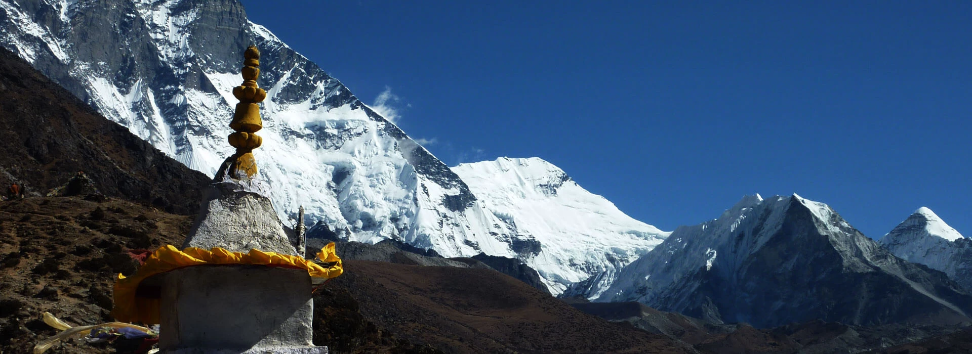
Island Peak's precise position places it in Nepal's Khumbu region, rising directly above the Chhukung Valley in eastern Sagarmatha National Park. At 6,189 meters (20,305 feet), the peak sits on the northern side of the Lhotse Shar ridge near Dingboche village and close to the main trail to Everest Base Camp, so climbers often include it in a wider expedition rather than as an independent climb.
In terms of its geographical location, Island Peak is a prominent peak located between several of the world's most popular and iconic mountains, such as Lhotse to the north, Baruntse to the east, and Ama Dablam to the southwest. The GPS reading puts the summit at about 27.9208° N latitude and 86.9352° E longitude, well within a dramatic amphitheater of peaks, giving the impression that the mountain is isolated from others when seen from the valley floor below.
At the base of the climb, you are following the route that most people in the Everest region take, through Namche Bazaar, Tengboche, and Dingboche, and then to the small settlement of Chhukung (4,730 m), the last place before you arrive at the mountain itself. The base camp of Island Peak is located at about 5,087-5,200 meters, often referred to as Pareshaya Gyab, and the practice of ascending to the higher base camp level (High Camp at 5,500-5,600 m) is on the way before the ultimate attempt to the summit.
No roads reach anywhere near Island Peak, and the entire approach happens on foot, following trails shared with trekkers heading toward Everest Base Camp for much of the journey before diverging into the quieter, less-traveled Chhukung Valley. This precise setting, between some of the most iconic peaks in the Himalayas but not so high that it requires advanced climbing skills, is part of the reason Island Peak has become one of the most popular introductory climbing goals in Nepal.
Why It's Called Island Peak (And Why Climbers Never Use Its Real Name)
Island Peak got its name in 1953, when a party of British climbers on the Everest expedition spotted it across the valley from Dingboche and realized that it stood on an otherwise unbroken ice sheet, just like an island in a sea of ice. Climbers quickly adopted the name, which has been fitting for over seven decades.
In 1983, Nepal's government officially adopted the correct geographic name of Imja Tse to link it formally to the local naming systems in the Khumbu region. Although this name was officially changed to English, the original name remained popular. It is still referred to almost solely as Island Peak by guidebooks, trekking companies, and climbers the world over and is only rarely mentioned by most people on the trails as Imja Tse.
The naming separation extends beyond Island Peak; many mountains in the Himalayas are also named by foreigners and have more recent official names given by the Nepalis, but few mountains have such a vast difference between official names and popular names. When you ask any climber in Chhukung which peak they’re trying to climb the next morning, almost everyone will answer: Imja Tse.
Today, standing in Dingboche, facing east towards the mountain, one can easily see what those expedition members saw decades ago. The glacial ice, which still covers much of the surrounding area and Island Peak itself, still looms over the landscape, as isolated and distinct as its nickname, a name that was almost an accident of being coined by passing mountaineers.
The Mountain Built for First Time Climbers
In many ways, Island Peak is a mountain that is built for first-time climbers, although it is certainly not without its fair share of cautions to be aware of before booking your trip. Although an Island Peak climb is technically a trekking peak, not a mountaineering excursion, there is no need to have any technical climbing ability to climb it, and guides regularly take novice climbers to the top every season. However, some veteran climbers take issue with the easy label for this reputation; after all, what you're climbing is true alpine climbing, just crammed into a shorter, better-supported frame than it would be on a large objective in the Himalayas.
The simplicity of the climb is based on the combination of the route and the equipment. Almost all trips have a special training day at Base Camp where you will learn how to use crampons and ice axes and how to climb and descend a fixed rope using a jumar. These are things you will use on summit day but not on any other day during your trip. Your Sherpa climbing team also ties ropes along the glacier and on the summit headwall, so you're not just relying on your own rope skills.
The actual route is a real glacier route, a crevasse awareness route, and finally a 150 m headwall climb at a 45- to 65-degree angle, which requires some real concentration but is easily accomplished with fixed ropes and guidance. No climbing or ice climbing skills beyond your training day are required, but comfort with movement on a rope, trust in equipment, and adequate physical exertion at 6,189 metres are necessary.
The chances of success for first-time climbers are reasonably high, ranging from 60 to 85 percent (and higher, depending on fitness, acclimatization, and weather), as long as they arrive well-conditioned with cardiovascular fitness and ideally some prior experience of high-altitude trekking, even if it was not a technical climb. The true challenge of Island Peak is much less about the climb being easy and more about the level of support, training, and safety infrastructure that is provided for you to help make such a climb a viable first summit for those willing to put in the effort and trust their guides with their lives.
What You Actually Climb: Glacier, Headwall, and a Summit Ridge
What you actually climb on summit day breaks down into three distinct stages, each demanding something different from your body and your nerves. Understanding the sequence before you're standing at the base of it makes the whole day considerably less intimidating.
Your climb begins in darkness, usually between midnight and 2 AM, leaving High Camp at roughly 5,600 meters for the steady push toward the glacier. This early stretch involves scrambling over loose rock and scree in the dark, headlamp-lit terrain that demands careful footing before you ever reach snow or ice. Reaching Crampon Point marks your first real transition, the spot where rock gives way to permanent snow and ice and where you strap on crampons and rope up with your climbing team for the first time.
From there, you're walking across the Imja Glacier itself, a genuinely crevassed stretch requiring roped travel between climbers in case anyone breaks through a hidden snow bridge. Your guide leads the way, testing terrain and choosing a route around visible crevasses, while you follow in a fixed line, ice axe in hand, moving steadily rather than quickly across terrain that punishes carelessness more than slow pacing.
The glacier eventually delivers you to the base of the headwall, the climb's genuine crux, and the section every account of Island Peak eventually circles back to. Roughly 150 meters of steep snow and ice, angled between 45 and 65 degrees depending on seasonal conditions, stand between you and the summit ridge. Your Sherpa climbing team fixes ropes up this entire section beforehand, and you ascend using a jumar, a mechanical rope clamp that slides up but locks against sliding back down, essentially climbing hand over hand while your legs do the harder work of kicking crampon points into the ice.
Once above the headwall, a narrow, exposed summit ridge leads the final stretch to the top, often requiring careful, deliberate steps given the drop on either side and the thin air making every movement feel heavier than it should. Reaching Island Peak's summit at 6,189 meters rewards you with an almost impossibly close view of Lhotse's south face, Makalu to the east, and Ama Dablam's distinctive silhouette, all visible from a vantage point few trekkers in the region ever reach.
Descending reverses the entire sequence, rappelling down the headwall using a figure-eight device rather than climbing it again, then retracing your path back across the glacier and down to High Camp, typically completing the full round trip from midnight departure to afternoon return in ten to twelve demanding hours.
Why Chhukung Became a Gateway to Island Peak
Chhukung is located in the Imja Valley at approximately 4,730 m (15,518 ft) high, in the shadow of some of the most spectacular mountains in the Everest region. Chhukung serves as the natural base for climbers preparing for the ascent of Island Peak, also known as Imja Tse, which stands at 6,189 m (20,305 ft) above the valley.
To climbers, Chhukung is more than just an overnight stop. The village offers a resting point, acclimatization, setting up climbing gear, and getting ready for the higher peaks that lie ahead. The base camp of Island Peak is further up the valley from here, making Chhukung one of the more familiar places to start the ascent.
There's a two-way link. Island Peak's summit has made Chhukung a popular destination for trekkers and mountaineers, and the village serves as a starting point for many visitors. The constant stream of people reaching Island Peak and the climbing routes around it has given rise to lodges, guides, porters, and climbing services.
Chhukung is also at a nodal point in the Khumbu. From here, trekkers can head on to Island Peak, hike to Chhukung Ri, or link up with more challenging routes like Kongma La and the Everest Three Passes. This makes the village more than a crossroad to one mountain; it's a small high-altitude crossroad where trekking routes and climbing objectives converge.
Hence, the Chhukung/Island Peak connection is closer than it seems: the mountain dominates the scene, while the village has become a part of the climbing cycle.
In the Shadow of Lhotse: Surrounding Valleys and Peaks
Standing at 6,189 m (20,305 ft), Island Peak, or Imja Tse, is one of the most spectacular summits in the Khumbu region of Nepal. One of the reasons why it is such a memorable mountain is its location. Island Peak is surrounded by glaciers, glacial lakes, and some of the highest peaks in the Himalayas.
The mountain scenery is much broader from the approach up to Base Camp and particularly from the higher elevations. The surrounding landscape around Island Peak is defined by Lhotse, Nuptse, Ama Dablam, Baruntse, and Makalu, which provide a climber with an idea of how far they have dug into the high Himalayas.
The Imja Valley: Island Peak's Alpine Setting
Island Peak is located in the Upper Imja Valley to the east of Dingboche and Chhukung in the Everest region. The trail slowly winds its way onto a smaller valley; the slopes are barren, and then there are the moraines and the glacial landscapes before getting into the Island Peak Base Camp.
The distinguishing feature of this landscape is the Imja Glacier that runs through the valley below the surrounding peaks. The combination of ice, rock, and steep mountain walls provides Island Peak with an almost isolated appearance, helping to explain why the mountain was once known as "Island Peak."
Imja Tsho is a nearby glacier that is also significant in the valley. The lake is about 5,000 m (16,400 ft) high and is formed by glacial meltwater trapped behind a moraine. Its presence adds another stark element to the already harsh, high-altitude surroundings.
The terrain gradually grows more icy, morainic, and massive rock and snow walls as climbers approach Base Camp. The location of Island Peak starts to make more sense here; it's not just a mountain on the side of the Everest route, it's a remote glacial basin surrounded by many great Himalayan summits.
Lhotse and Nuptse: The Giants to the North
The highest mountains near Island Peak are Lhotse and Nuptse. They rise to the north and northwest.
Lhotse is the world's fourth highest peak at 8,516 m (27,940 ft) and one of the most impressive backdrops to the Island Peak landscape. The south face is so large that it rises up to the upper Imja Valley, which creates a contrast with the comparatively smaller Island Peak (6,189 m).
Lhotse Shar, another giant wall, stretching to about 8,383 m (27,503 ft), stands close to it. Along with Lhotse, these peaks provide the immense scale of the northern skyline of Island Peak.
Further west, Nuptse stands at 7,861 m (25,791 ft), further reinforcing the jagged lines of the high Himalaya. These mountains are especially remarkable from the Island Peak region, where a 6,000m climbing peak is under a sky filled with mountains over 7,800m and 8,500m.
Ama Dablam is the iconic peak on the approach to Mt. Everest. The Ama Dablam is the iconic peak on the approach to Mt. Everest.
Ama Dablam: The Iconic Peak Along the Approach
Ama Dablam at 6812 m (22,349 ft) is one of the most photographed mountains in the Everest region, and the "double-ridged" profile is characteristic of it. The journey to Dingboche and Chhukung offers views of its rugged peak and imposing ridges from many vantage points.
Ama Dablam is not directly in front of Island Peak, but it contributes to the overall scenery of the valley of Imja. For many trekkers, the visuals of Ama Dablam moving across the trail are a part of the story when they enter the high Khumbu.
Baruntse and Makalu on the Eastern Horizon
From the Island Peak area, the mountains appear even more vast. Baruntse (7162 m/23497 ft) stands above the glaciers and ridges, while further east is Makalu (8485 m/27838 ft).
Makalu is the fifth highest peak in the world and is likely to be visible from the highest point in the Island Peak area, depending on the weather and visibility. With its unique pyramid form, it becomes the largest of the many giants that make up its extraordinary skyline.
The views of these distant peaks also shed light on the location of Island Peak. The mountain is often thought of as belonging to the Everest area, but there is much more beyond Everest! The view then stretches through several significant stretches of the Himalayan ranges, making one climbing goal more of a panorama of mountains from Island Peak.
Island Peak Within the Himalayan Landscape
This is what makes the location of Island Peak so spectacular. Island Peak is not just a 6189 m peak; it's what it is surrounded by. It is in the Imja Valley; its immediate surroundings are defined by glaciers and moraines, and enormous peaks like Lhotse, Nuptse, Ama Dablam, Baruntse, and Makalu form the skyline.
For those who ask, "Where is Island Peak?" the answer is more than a map point. Island Peak is a mountain that stands in the upper Imja Valley, far from the beaten track in the Khumbu, with some of the most spectacular high-altitude scenery in the world.
How to Reach Island Peak from Kathmandu
How to reach Island Peak from Kathmandu starts with the same short mountain flight used across the wider Everest region, since no road network extends anywhere near the Khumbu's high valleys. Your journey begins with a 30 to 40 minute flight from Kathmandu to Lukla, landing at Tenzing-Hillary Airport before the rest of your approach continues entirely on foot.
From Lukla, your trail follows the familiar corridor most Everest region trekkers know well, climbing through Phakding and Namche Bazaar before continuing toward Tengboche and Dingboche. Past Dingboche, the route diverges from the main Base Camp trail, branching east into the Chhukung Valley rather than continuing north toward Lobuche and Gorak Shep.
Chhukung itself sits at 4,730 meters, the last proper settlement before the mountain, and most itineraries include a rest day here for acclimatization and final gear checks before pushing higher. From Chhukung, you continue to Island Peak Base Camp at roughly 5,100 meters, a trek of three to four hours across increasingly rocky, high-altitude terrain, before a final push to High Camp ahead of your summit attempt.
The full journey from Kathmandu to Base Camp typically takes eight to nine days of steady trekking, allowing gradual acclimatization through the same villages Everest Base Camp trekkers pass through, before the final stretch into Chhukung's quieter, less-traveled valley sets you up for the climb itself.
When the Mountain Lets You In: Best Time to Climb Island Peak
When the mountain lets you in depends heavily on seasonal stability, since Island Peak's glacier and headwall conditions shift considerably depending on snowfall and temperature throughout the year. Autumn, spanning late September through November, offers the most reliable window, with stable weather, firm snow conditions on the headwall, and minimal risk of fresh snowfall destabilizing the route.
Spring, running March through May, provides a similarly strong climbing season, particularly before late spring's increasing afternoon cloud cover and warmer temperatures begin softening snow and ice conditions on the upper mountain. Both seasons see the heaviest climbing traffic, meaning fixed ropes stay well maintained and established, though it also means busier conditions at Base Camp and High Camp.
Winter months between December and February technically remain climbable, but far fewer teams attempt it, given bitterly cold temperatures and the added technical challenge of ice conditions at their hardest and most unforgiving. Monsoon season, June through August, rules out climbing almost entirely, since heavy snowfall and poor visibility make the glacier crossing and headwall dangerously unpredictable.
Given how much the technical section depends on stable snow and ice, autumn edges out as the generally preferred window, offering the most consistent balance of manageable conditions and reliable weather for summit attempts.
The Paperwork Above the Trek: Island Peak Permits
The paperwork above the trek adds a layer most Everest region visitors never need to think about, since Island Peak requires climbing permits beyond the standard trekking documents covering the rest of your journey. Alongside the usual Sagarmatha National Park entry permit, around $30 USD, and the Khumbu Pasang Lhamu Rural Municipality permit, around $20 USD, climbers need a separate Nepal Mountaineering Association climbing permit specifically for Island Peak itself.
This climbing permit cost varies by season, generally running higher during peak spring and autumn climbing windows and lower during off-season months, typically ranging from $250 to $400 USD depending on timing and group size. Unlike standard trekking permits checked at trailside posts, this permit authorizes your actual summit attempt and must be arranged before you leave Kathmandu, since it isn't something you can pick up along the trail.
A licensed climbing guide becomes non-negotiable here too, beyond Nepal's general trekking guide requirement. Island Peak's technical terrain, fixed ropes, glacier travel, and the headwall itself demand a guide specifically experienced in peak climbing rather than standard trekking alone someone capable of fixing ropes safely and managing the technical sections your ascent depends on.
Nepal Nomad arranges all three permits- national park, municipality, and the NMA climbing permit- as part of your package, sorting the paperwork in Kathmandu before you ever set foot on the trail, so your only responsibility is providing a passport scan and confirming your climbing dates well in advance.
Your First Summit Starts Here
Island Peak now sits clearly mapped in your mind, from its exact location in the Chhukung Valley to the glacier crossing, fixed ropes, and final headwall that separate this mountain from a standard Everest region trek. Standing at 6,189 meters, the peak rewards genuine preparation with a view few trekkers in the region ever earn, Lhotse's south face rising close enough to feel within reach, Makalu and Ama Dablam framing the horizon on either side.
Whether you're drawn to Island Peak as your first real introduction to mountaineering, curious how it compares against Mera Peak as a starting objective, or simply want an honest account of what the climb actually demands, your path forward now feels considerably clearer than it did before reading this guide. You don't need prior climbing experience to stand at the summit, only genuine fitness, a willingness to trust your guide completely, and the patience to let a training day at Base Camp turn you into someone capable of climbing it.
Nepal Nomad's experienced climbing guides handle every detail of your journey, from permits and acclimatization pacing to fixing the ropes that carry you safely up the headwall itself. Reach out to Nepal Nomad and let your first summit take shape, turning today's curiosity into tomorrow's genuine mountaineering achievement.