Where Is Cho La Pass and How High Does It Sit
Where is Cho La Pass a question every trekker planning a Gokyo to Base Camp crossing eventually asks, given how central this route sits within the Khumbu's high-altitude network. The pass reaches 5,420 meters (17,782 feet), positioned almost exactly between the villages of Dzongla to the east and Dragnag to the west, forming the critical link connecting Everest Base Camp's classic trail with the turquoise lakes of Gokyo Valley.
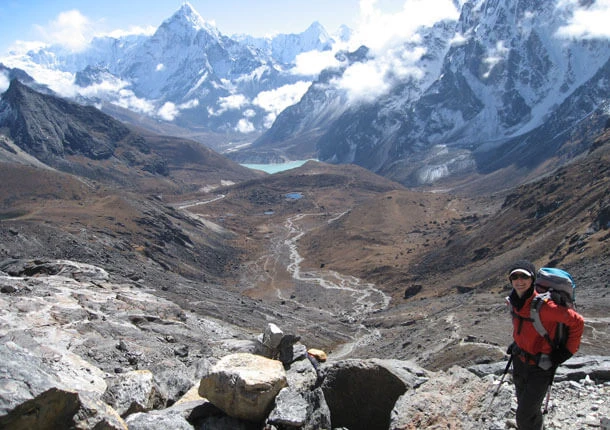
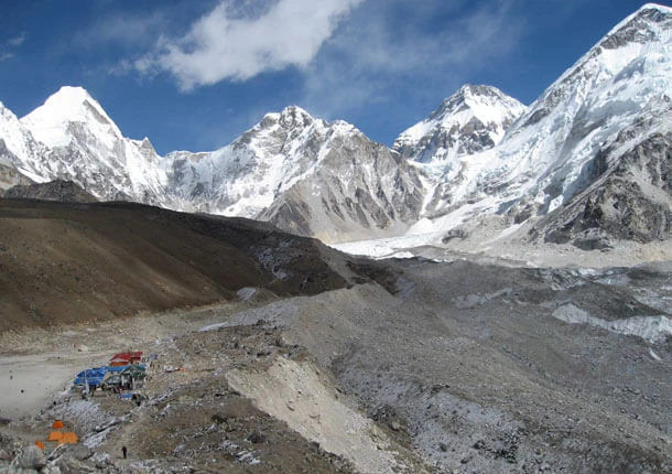
Geographically, Cho La sits roughly in the middle of the three major Everest region passes, both in elevation and location, bridging the gap between Renjo La further west and Kongma La to the east. Unlike a single dramatic peak, the pass itself cuts through a narrow, glacier-draped gap in the ridgeline, forcing trekkers directly across compacted snow and ice near its highest point rather than following a purely rocky trail throughout.
Reaching Cho La typically means approaching from Dzongla if you're heading toward Gokyo, or from Dragnag if traveling the opposite direction toward Everest Base Camp. Both approaches converge at the same narrow, ice-covered summit, where trekkers pause briefly among prayer flags before continuing the demanding descent on the opposite side.
Oxygen levels at this elevation drop to roughly half of sea-level concentration, compounding the physical demands already introduced by the glacier crossing itself. Understanding exactly where Cho La sits and how its geography differs from Renjo La and Kongma La helps set realistic expectations before committing to a route that genuinely tests both fitness and technical comfort on ice.
Why Cho La Is Considered the Most Technical of the Three Passes
Why Cho La is considered the most technical of the three passes comes down to one defining feature its counterparts simply don't have: an actual glacier crossing near the summit. Renjo La and Kongma La both stay on rock and scree throughout, but Cho La demands walking across genuine ice and compacted snow, transforming the final stretch before the pass into something closer to mountaineering than standard high-altitude trekking.
Steep, exposed scrambling sections flank both sides of the glacier itself, requiring careful hand and foot placement across loose rock before the terrain shifts suddenly underfoot. Crampons or microspikes often become necessary depending on recent snowfall and ice conditions, equipment rarely needed anywhere else along the standard Everest Base Camp or Gokyo routes, adding a genuine technical skill requirement beyond simple fitness and acclimatization.
Weather amplifies every risk factor already present at this altitude. Fresh snowfall can bury crevasses or hide unstable footing across the glacier, while sudden wind and reduced visibility near the summit make navigation considerably harder than on Renjo La's more straightforward rocky ascent. Guides familiar with current ice conditions become essential here, since the safest route across the glacier shifts from week to week depending on temperature and recent weather patterns.
Comparing difficulty ratings across the three passes places Cho La firmly above Renjo La and roughly on par with or slightly below Kongma La, depending on current glacier conditions during your specific crossing window. Trekkers researching Renjo La Pass as a comparison point quickly notice the difference in tone between the two guides, since Cho La's technical demands genuinely warrant more serious preparation, proper gear, and realistic expectations before attempting the crossing.
The Ice Section: What Crossing the Cho La Glacier Actually Involves
The ice section defines Cho La's reputation more than any other single feature along the crossing, transforming roughly 150 to 200 meters of the route into a genuine glacier walk rather than ordinary mountain trekking. Approaching from Dzongla, the trail climbs steeply over loose rock and boulders before suddenly giving way to a wide expanse of snow and compacted ice, where trekking poles get exchanged for careful, deliberate footsteps guided closely by your guide's lead.
Crampons or microspikes typically go on before stepping onto the glacier itself, strapped securely over trekking boots to provide grip across the hardened, often slippery surface. Snow depth and ice conditions vary considerably depending on recent weather, sometimes requiring a rope line for additional security, particularly during early morning crossings when overnight freezing hardens the surface into a harder, more slippery consistency than afternoon conditions typically produce.
Crevasses remain a genuine concern beneath fresh snowfall, though established guiding routes generally avoid the most hazardous sections given years of accumulated local knowledge about where the ice stays stable. Moving in a single-file line behind your guide, maintaining steady spacing, and avoiding any urge to rush across the ice all matter considerably more here than anywhere else along the broader Everest Three Passes circuit.
Once across, a final steep descent over loose rock and scree leads toward Dragnag, marking the technical end of the crossing even as legs continue absorbing the physical toll of a demanding, multi-hour effort. Trekkers who approach the ice section with patience and proper gear typically find it manageable despite its intimidating reputation, though underestimating its seriousness remains one of the most common mistakes made along this particular stretch of the Khumbu.
Cho La as the Connector: Why It's the Pass Most Trekkers Combine with EBC and Gokyo
Cho La as the connector explains why this particular pass sees far more foot traffic than Renjo La or Kongma La despite its added technical difficulty. Sitting almost directly between Everest Base Camp's classic trail and the turquoise Gokyo Valley, Cho La offers the most efficient link between the region's two most celebrated destinations, letting trekkers experience both without backtracking or adding significant extra days to their itinerary.
Trekkers starting from Base Camp typically cross from Dragnag toward Dzongla, continuing onward into the Gokyo Lakes for turquoise lake views and the Gokyo Ri sunrise climb before looping back through Namche Bazaar. Others approach the opposite direction, exploring Gokyo first before crossing Cho La toward Base Camp itself, a route Nepal Nomad's Everest Chola Pass Trek builds around specifically, combining both destinations into a single, well-paced itinerary.
Because the crossing sits so centrally within the Khumbu valley, trekkers following either direction typically pass through Tengboche Monastery along the way, and those extending their journey further west sometimes detour toward Thame, adding deeper cultural immersion to an already well-connected route between the region's two main trekking corridors.
Choosing to cross Cho La as a connector rather than skipping straight between destinations by retracing your steps rewards you with efficiency, though it demands accepting genuine technical risk in exchange for that shorter, more direct path between two of the Khumbu's most rewarding regions.
Safety Considerations and Why a Guide Matters on Cho La
Safety considerations around Cho La carry genuine weight given the glacier crossing and unpredictable ice conditions defining the pass's final approach. A licensed, experienced guide becomes essential rather than simply helpful here, since navigating shifting snow cover, identifying stable footing across the ice, and recognizing when conditions turn unsafe demands local knowledge no guidebook or map can fully replace.
Weather changes fast at this altitude, and conditions considered safe one morning can deteriorate within hours given fresh snowfall or sudden wind. Guides familiar with Cho La's current state typically check conditions the evening before attempting the crossing, sometimes delaying departure entirely if ice looks unstable or visibility drops below safe thresholds, a level of real-time judgment that shapes every decision made on pass day.
Altitude sickness risk stays consistent with other high-altitude crossings in the region, though the added physical and mental strain of navigating ice increases overall exhaustion, making early symptom recognition even more important. Nepal Nomad's guides come equipped specifically for glacier travel, carrying ropes, basic ice safety gear, and first-aid supplies suited to the pass's unique demands, giving trekkers a genuine safety net unavailable to those attempting the crossing independently.
Group pacing matters considerably on Cho La, since moving too quickly across ice increases fall risk, while moving too slowly extends exposure to cold and wind at altitude. Trekkers attempting Cho La benefit enormously from guides who manage this balance instinctively, timing the crossing, reading the ice, and adjusting pace in real time to keep the entire group moving safely across one of the Khumbu's most respected high-altitude challenges.
Real Trekker Accounts: What People Don't Expect About Cho La
Real trekker accounts of crossing Cho La consistently mention one surprise above all others: the ice section feels far more mentally demanding than physically exhausting. Trekkers often describe the actual glacier crossing as shorter than expected, yet far more nerve-wracking, since every step requires deliberate focus rather than the steady, rhythmic walking pace common across most of the Everest region's trails.
Many trekkers admit underestimating how disorienting early morning starts feel when combined with headlamp-lit scrambling over loose rock before sunrise. Cold hands fumbling with crampon straps in near-freezing temperatures, guides calling out careful instructions across the ice, and the sudden hush that falls once everyone reaches solid ground again on the far side all feature prominently in trekker recollections of the crossing.
Descuts on the Dzongla side surprise plenty of hikers too, with several noting the steep, loose scree descent toward Thangnak or Dragnag feels tougher on tired knees than the ice crossing itself. Trekking poles, barely needed during the glacier section, suddenly become essential again once solid rock returns underfoot.
Perhaps most consistently, trekkers describe an unexpected sense of relief and pride once safely across, often ranking Cho La as the most memorable single day of their entire Everest region journey, even above summiting Kala Patthar or reaching Base Camp itself. The blend of genuine challenge, brief but intense technical demand, and dramatic scenery on both sides leaves a distinct impression rarely matched by the region's other trekking days.
Dzongla vs Dragnag: Which Side Should You Approach From
Dzongla vs Dragnag comes down to travel direction more than any meaningful difference in difficulty, since both sides eventually lead across the same glacier and demand identical preparation regardless of which way you're heading. Trekkers traveling from Everest Base Camp toward Gokyo typically start from Dzongla, a small settlement offering basic teahouse accommodation and serving as the final rest stop before the early morning push toward the pass.
Approaching from Dragnag instead suits trekkers heading the opposite direction, starting their journey in Gokyo before crossing toward Base Camp. Dragnag sits slightly lower and less developed than Dzongla, with fewer lodging options, making advance planning through a trekking agency particularly useful for hikers choosing this direction.
Physically, the climb from Dzongla involves a steadier, more gradual ascent before reaching the glacier, while the approach from Dragnag tends to feel steeper and more abrupt early on, given the terrain's natural contours on that side of the pass. Neither direction offers a meaningfully easier crossing once you reach the ice itself, since the technical demands of the glacier stay identical regardless of which side you started from.
Choice ultimately depends on your broader itinerary rather than any inherent advantage either direction offers. Trekkers combining Base Camp first, then Gokyo, naturally approach from Dzongla, while those prioritizing Gokyo's turquoise lakes early in their journey find Dragnag the more logical starting point, both converging at the same demanding, ice-covered summit regardless of direction chosen.
The Gear Debate: Do You Really Need Crampons for Cho La?
The gear debate around crampons for Cho La comes up constantly among trekkers planning their crossing, largely because the answer genuinely depends on conditions rather than following a fixed rule. Under favorable, dry conditions with minimal recent snowfall, some trekkers cross the glacier section using only sturdy boots and trekking poles, since the ice occasionally stays firm enough underfoot without additional traction gear.
That said, relying on favorable conditions alone carries real risk given how quickly weather shifts at this altitude. Fresh snowfall or overnight freezing can transform a manageable crossing into a genuinely slippery, hazardous stretch within hours, making lightweight microspikes a sensible middle-ground option many guides recommend carrying regardless of forecasted conditions. Full mountaineering crampons, while rarely necessary for standard Cho La crossings, sometimes get requested by trekkers who prefer maximum traction regardless of added weight and cost.
Renting gear in Namche Bazaar or Kathmandu remains the most practical solution for most trekkers, avoiding the expense and luggage weight of purchasing specialized equipment for a single crossing. Guides typically assess current glacier conditions the evening before pass day and advise accordingly, meaning the final decision often comes down to their real-time judgment rather than a decision made weeks in advance from home.
Ultimately, packing microspikes as a lightweight precaution, even if conditions end up not requiring them, costs little in comparison to being caught unprepared on genuinely icy terrain. Trekkers who treat crampon decisions as guide-led rather than personally predetermined tend to navigate this particular gear debate with the least stress and the safest outcome.
Best Time to Cross Cho La Pass
Best time to cross Cho La Pass falls within the same two primary trekking windows favored across the wider Everest region, spring and autumn, though ice conditions make season selection considerably more important here than on Renjo La or Kongma La. Autumn, spanning late September through November, generally offers the most stable glacier conditions of the year, since accumulated monsoon snow has typically melted or compacted by this point, leaving firmer, more predictable footing across the ice section.
Spring season, running March through May, provides a similarly favorable window, though early spring crossings sometimes encounter leftover winter snow that hasn't fully consolidated yet. Later spring months, particularly April and May, generally offer safer glacier conditions as temperatures rise and snow settles into a firmer, more stable surface underfoot.
Winter months between December and February transform Cho La into a considerably more serious undertaking, with heavy snow accumulation often burying the usual crossing route entirely and dramatically increasing avalanche and crevasse risk. Only highly experienced trekkers with proper technical gear and an exceptionally cautious guide should attempt the pass during this window, and even then, conditions sometimes make crossing genuinely inadvisable regardless of preparation.
Monsoon season from June through August rules out attempting Cho La almost entirely, given persistent snowfall at altitude, poor visibility, and dangerously unstable glacier conditions that make the ice section unpredictable even for experienced guides. Trekkers planning their journey around Cho La should prioritize autumn first for the most reliable ice conditions, followed by late spring, while treating winter and monsoon as genuinely high-risk windows better avoided unless circumstances leave no other choice.
Standard Itinerary for Crossing Cho La Pass
The standard itinerary for crossing Cho La Pass typically runs as part of Nepal Nomad's 19-day Everest Cho La Pass Trek, combining Everest Base Camp, the technical pass crossing, and Gokyo Lakes into a single continuous journey. Trekkers short on time can also opt for a shortened heli version, trading the multi-day return trek for a scenic flight straight out of Gokyo.
Full Trekking Itinerary (19 Days)
Day 1 : Kathmandu Arrival (4,462 ft / 1,360 m)
Day 2 : Kathmandu Sightseeing Tour (4,462 ft / 1,360 m)
Day 3 : Fly to Lukla, Trek to Phakding (9,383 ft / 2,860 m to 8,701 ft / 2,652 m)
Day 4 : Phakding to Namche Bazaar (11,306 ft / 3,446 m)
Day 5 : Acclimatization Day in Namche Bazaar (11,306 ft / 3,446 m)
Day 6 : Namche Bazaar to Tengboche (12,664 ft / 3,860 m)
Day 7 : Tengboche to Dingboche (13,399 ft / 4,084 m)
Day 8 : Acclimatization Day in Dingboche, Hike to Nagarjun Hill (16,732 ft / 5,100 m)
Day 9 : Dingboche to Lobuche (16,175 ft / 4,930 m)
Day 10 : Lobuche to Gorak Shep, Everest Base Camp, Back to Gorak Shep (17,575 ft / 5,357 m)
Day 11 : Gorak Shep to Kala Patthar, Trek to Dzongla (18,208 ft / 5,550 m to 15,846 ft / 4,830 m)
Day 12 : Dzongla to Cho La Pass, Trek to Thagnak (17,610 ft / 5,368 m to 15,420 ft / 4,700 m)
Day 13 : Thagnak to Gokyo (15,584 ft / 4,750 m)
Day 14 : Explore Gokyo Ri (17,585 ft / 5,360 m)
Day 15 : Gokyo to Dole (13,248 ft / 4,038 m)
Day 16 : Dole to Namche Bazaar (11,286 ft / 3,440 m)
Day 17 : Namche Bazaar to Lukla (9,186 ft / 2,800 m)
Day 18 : Fly Lukla to Kathmandu (4,462 ft / 1,360 m)
Day 19 : Kathmandu Final Departure
Heli Option (14 Days)
Day 1 : Kathmandu Arrival (4,462 ft / 1,360 m)
Day 2 : Fly to Lukla, Trek to Phakding (9,383 ft / 2,860 m to 8,701 ft / 2,652 m)
Day 3 : Phakding to Namche Bazaar (11,306 ft / 3,446 m)
Day 4 : Acclimatization Day in Namche Bazaar (11,306 ft / 3,446 m)
Day 5 : Namche Bazaar to Tengboche (12,664 ft / 3,860 m)
Day 6 : Tengboche to Dingboche (13,399 ft / 4,084 m)
Day 7 : Acclimatization Day, Hike to Nagarjun Hill (16,732 ft / 5,100 m)
Day 8 : Dingboche to Lobuche (16,175 ft / 4,930 m)
Day 9 : Lobuche to Gorak Shep, Everest Base Camp, Back to Gorak Shep (17,575 ft / 5,357 m)
Day 10 : Gorak Shep to Kala Patthar, Trek to Dzongla (18,208 ft / 5,550 m to 15,846 ft / 4,830 m)
Day 11 : Dzongla to Cho La Pass, Trek to Thagnak (17,610 ft / 5,368 m to 15,420 ft / 4,700 m)
Day 12 : Thagnak to Gokyo (15,584 ft / 4,750 m)
Day 13 : Explore Gokyo Ri, Helicopter Flight Gokyo to Kathmandu (17,585 ft / 5,360 m)
Day 14 : Kathmandu Final Departure
Note: There is also another heli-route-the vice versa itinerary that starts from Gokyo and ends at Gorek Shep.
Choosing between the two comes down to time and budget. The full trekking itinerary retraces the route on foot back through Dole and Namche Bazaar, while the heli option lifts directly out of Gokyo once Gokyo Ri is complete, cutting five days off the total journey in exchange for the added cost of a helicopter charter.
Permits and Regulations for Cho La Pass
Permits and regulations for Cho La Pass match the same requirements covering the rest of the protected Khumbu region, since the crossing sits entirely within Sagarmatha National Park boundaries. Every trekker needs the national park entry permit, priced around $30 USD, alongside the Khumbu Pasang Lhamu Rural Municipality permit, costing approximately $20 USD, both checked at designated points along the route regardless of which direction you approach the pass from.
Nepal's 2023 regulation requiring every trekker to hire a licensed guide applies with particular weight here, given the genuine technical demands of the glacier crossing itself. Route finding across the ice shifts season to season as conditions change, and recognizing unstable sections requires current, local knowledge that goes well beyond standard trekking experience, making professional guidance considerably more than a legal formality on this specific route.
Travel insurance deserves special attention when planning a Cho La crossing. Standard policies often cap coverage well below the altitude this route demands, so confirming your policy covers activities up to at least 6,000 meters, alongside emergency helicopter evacuation, matters significantly more here than on gentler treks. Some insurers also draw a distinction between standard trekking and activities involving glacier travel or crampon use, making it worth checking your policy's fine print before departure rather than after an emergency arises.
Purchasing permits typically happens through your trekking agency before departure, streamlining the process considerably compared to arranging them independently. Trekkers booking via Nepal Nomad have permits, guide arrangements, and insurance guidance handled as part of the package, removing bureaucratic hassle from a journey that already demands significant physical and mental preparation.
Frequently Asked Questions About Cho La Pass
What can you see from the top of Cho La Pass?
The summit rewards you with close-up views of Cholatse and Ama Dablam, alongside a sweeping glacial landscape stretching in every direction, a genuinely different panorama compared to the wider, more distant peaks visible from Renjo La further west.
How does Cho La Pass connect to the Gokyo Lakes?
Descending from the pass toward Thagnak leads directly into the Gokyo Valley, home to the turquoise Gokyo Lakes, among the highest freshwater lake systems on Earth. Crossing Cho La remains the most direct way to link Everest Base Camp with this remote lake system without backtracking.
Is Cho La Pass harder than the standard Everest Base Camp trek?
Yes, considerably. The Everest Base Camp trek stays entirely on rock and established trail throughout, while Cho La adds genuine glacier travel, technical scrambling, and elevated risk that pushes well beyond what standard Base Camp trekking demands.
Can you skip Cho La Pass and still visit Gokyo?
Yes, though it requires a separate journey, either flying back to Kathmandu after Base Camp and starting fresh toward Gokyo, or approaching through Renjo La instead. Trekkers wanting both destinations connected within one continuous walk generally choose Cho La specifically for that reason.
What time of day should you start crossing Cho La Pass?
Most crossings begin before sunrise, typically leaving Dzongla by six or seven in the morning to reach the glacier section while ice stays firm and before afternoon wind and cloud cover set in.
Do you need prior glacier experience to cross Cho La Pass?
No. Your guide provides instruction on proper crampon use and safe glacier walking before the crossing itself. Genuine cardiovascular fitness and a willingness to follow instructions closely matter far more than prior technical experience.
What happens if weather makes the pass unsafe on your scheduled day?
Guides typically build flexibility into the itinerary for exactly this reason, delaying the crossing a day at Dzongla rather than attempting it regardless if ice or visibility looks unsafe.
Are there teahouses along the actual crossing?
No. Cho La has no accommodation or rescue points anywhere along the route between Dzongla and Thagnak, meaning you're committed to reaching one side or the other once the crossing begins, which is why proper insurance and an experienced guide matter so much here.
Is Cho La Pass senior-friendly or kid-friendly?
Cho La demands genuine technical comfort alongside physical fitness, making it unsuitable for young children and challenging even for many otherwise fit seniors. Families and older trekkers seeking a gentler Everest region experience typically find better fits in the standard Base Camp trek or the less technical Renjo La crossing instead.
Cho La Pass: The Crossing That Tests What You're Made Of
Cho La Pass now sits clearly mapped in your mind, from its exact location and elevation to the glacier crossing, gear demands, and seasonal conditions that separate this pass from anything else in the Khumbu. Standing at 5,420 meters, Cho La rewards genuine preparation with views of Cholatse and Ama Dablam rising above a landscape few trekkers ever cross on foot, earning its reputation as the most technically demanding of Everest's three major high passes.
Whether you're drawn to Cho La as the most efficient link between Base Camp and Gokyo, curious how it compares against Renjo La's gentler ascent, or simply wanted an honest account of what the ice section actually demands, your path forward now feels considerably clearer than it did before reading this guide. Fit, well-prepared trekkers who respect the pass's genuine technical risk find crossing it among the most rewarding single days anywhere in the Everest region.
Nepal Nomad's experienced local guides handle every logistical and technical detail of your journey, from permits and glacier-ready gear to real-time decisions about ice conditions on crossing day itself. Reach out to Nepal Nomad and let your own crossing of Cho La take shape, turning today's curiosity into tomorrow's genuine Himalayan achievement.